
Today was the first day since I got here in May that I was caught up on my chores, my sleep, my work, and my financial goals and I really wanted to do something special. The obvious choice was to visit some more Mayan ruins. Thankfully, there are some only 30 minutes away!
Interestingly, my hamlet in SK is best known for being home to one of two sites in North America with petroglyphs on a horizontal surface. You could call that the “place where there is writing on the stones.” Well, Dzibilchaltún, the name of the Mayan city nearest where I’ve chosen to put down my first Mexican roots means… the “place where there is writing on the stones.” What a coincidence.
Dzibilchaltún is ridiculously accessible, just 5KM from the Progreso/Mérida highway on good roads.

Access to the site is quite pricy — $25 for parking + $142 for admisssion. Mexicans and permanent residents get free access on Sundays. There is no incentive for folks from the area who are temporary residents or who come down every winter. That’s rather a shame because it makes it less likely that I would want to come back here with guests. It would be nice to be able to buy a yearly membership or to get a break on admission for future visits as it’s such a lovely place to get out of the city.
From the parking lot, you take a meandering path in the forest to get to the ticket booth.


There was quite a bit of signage throughout the site in Spanish, Maya, and English. So any info I share is from there since I opted not to take a $350 (or 25USD…) guided tour. I learned a lot at Uxmal, but did not get much time to wander around. Today, I just wanted to enjoy being outside and poke through ruins at my own pace rather than hear a lot of information.
Dzibilchatún, with its proximity to the northern coast of Yucatán had both a marine and agricultural economy. The site was occupied from about 300 B.C. and was populated until the Spanish Conquest. It peaked from 600 to 900 A.D, with a population of 20,000. It was about 9KM square and had a concentric layout. The central part of the settlement had grand plazas connected by roadways in an area of 3KM square. It was in the central part that lived the administrative and religious elite. The population lived around the core. It was this population that contributed to change the concept of “ceremonial centre” to one of “urban centre.”
Here’s a map of the site:

Like at Uxmal, there are two separate fees to pay to enter the site. Here, I was able to pay the whole thing at one window and then collect my ticket at the second window. After that is a booth where you can hire guides and beyond that is a covered market area (very disappointing) and clean bathrooms.

Behind the entrance area, you can access the “archaeological zone.” To the right are the ruins I explore below as well as the cenote, which, unfortunately, was closed today. To the left is another ruin we’ll get to in a bit.
This is the area of the grand plaza. It covers about 12,240 metres and would have had a stucco floor (!). It was surrounded by buildings with stairs leading to the plaza. Most of the surviving buildings date to the early Middle Ages, 600 to 1,000 A.D., but a couple date to 1000 to 1200 A.D.


The cenote is a popular local swimming spot, but it seemed a bit uninviting to me.

Can you spot the giant iguana?


On this site are the ruins of a 16th century chapel. As a reminder, that’s the time of the Renaissance. You don’t need to go to Europe to visit old buildings!


These are part of the ruins of a 17th century ranch.


I must have been a mountain goat in a past life. Up I went!


I’m starting to think about getting myself a selfie stick. Not. 🙂

The wooden lintels make me suspect that these structures were also part of the ranch.


Back of the chapel.


There were way too many people to climb the pyramid, so I decided to head to the other part of the site.

It was only about 10:30 and while the sun had been unrelenting since I’d gotten up at 8:00, there was a wonderfully cool breeze running through the site, making it very comfortable. I walked on a 20 metre wide road called a “sacbe.” It begins at the east of the central square and connects 400 metres later with the building called the “Seven Dolls.” The road was mainly in use from 600 to 100 A.D. There are 11 of these roads in Dzibilchaltún, all beginning in the centre and going to peripheral structures, giving the site its urban character. The inner roads have been interpreted as evidence of ties between families.


I took a short detour into the woods to see what’s left of the housing complex, a cluster of buildings in an area of about 4,000 square meters. The dwellings had different heights, speaking to different social status. The inhabitants were buried beneath the floors of the platforms. There really wasn’t much to see, but I enjoyed the shady trail.


Back at the main road, I came across Structure 12, a quadrangular platform with access points on all four sides. Upon it is a monolith, which would have been decorated with stucco and functioned as one of the 20 stelle on the site.


In front of the Seven Dolls are three adjoining rooms aligned with a double open hall. To the south is another double room and to the east a single room. They were inhabited circa 800 A.D. Beneath their floor were offerings of shells, fishbones, stingray tails, small objects made out of green stones, grey obsidian, and other marine materials.

The Seven Dolls building owes its name to an offering of seven coarsely made dolls found inside. It is a one-story quadrangular building with a central chamber surrounded by a corridor. The roof was tower-like and it projected itself upwards from the vaulting. It had four access points and a window to the side of each entrance facing east and west, giving it the characteristics of an astronomical observatory. It was constructed on a pyramidal pedestal, with sloping corners, with sets of steps on all four sides. The frieze of the building was decorated with eight stuccoed masks upon a base of carved stone, two intertwined serpents and glyphs, and beads, feathers, and sea creatures in modelled stucco. Towards 800 A.D., it was filled with stones and covered by another, larger, building, whose remains still partially cover it.


I then headed back towards the entrance to find the museum, when another stone structure caught my eye. I quickly realised from its roof that it was a tad more modern! 🙂


The museum is in two buildings, is small, and is really informational. The Grand Museo del Mundo Maya is really a must, but this little museum does a great job of giving the folks who are coming to Dzibilchatún as a day trip from the cruise ships a primer on the Mayans.
The museum starts by situating the Maya in their geographical context, explaining that there are very distinct ecosystems in their world. Where I am, in northern Yucatán, is more desertic and flat, but you get into mountains and rainforests as you move south towards Honduras.
The serpent is a very important part of their mythology.

This is a hoop from a ballgame that I learned today was usually a prelude to human sacrifice.

Map of Mayan settlements in Yucatán. I still can’t believe that I was taught in school that there is no history in North America before the Europeans came.


There are a lot of parallels between the Maya and the Egyptians, such as the fact that they wrote in hieroglyphs set in cartouches. The Dresden Codex is the Maya equivalent of the Rosetta Stone that decoded Egyptian hieroglyphs.
Pretty purple flowers by the entrance to the second half.

While the first half was about the Maya in general, the second half was more about Dzibilchatún and also the Spanish Conquest.
Here are the Seven Dolls!

I’m not going to retype all of the information I got in the museum, but here is something of particular interest. “Scarcely five metres above sea level, very close to the coast, located on the difficult, calcareous and porous soil of north Yucatán, Dzibilchaltún is an example of a successful Maya urban dwelling. It was a challenge to life. Without rivers to justify the decision to build, its inhabitants obtained water from more than a hundred wells and some neighbouring sinkholes. The largest of the later, the cenote of Xlacah in the very centre of the city, quenched thirst of rulers, priests, merchants, and pilgrims.”
The section about the conquest was very well done, showing how the Maya evolved and yet kept old traditions and knowledge alive.
The Maya were expert stone craftsmen and their “artistic ability was demanded as tribute,” to build churches, mansions, streets, and aqueducts of Spanish towns.


I’m trying to remember where else I saw this system of currency, where employees of a hacienda were paid with tokens that could only be used at that hacienda’s store.

A bale of henequen, which is an agave (yes, the same stuff used to make tequila).

Very old map of Mérida.

There was an ecological path outside of the museum… that was closed. 🙁

There were a couple of dwellings to check out.


There’s an impressive meeting area with a woven roof.

And a lovely covered walkway back to the main entrance.


I spent about two full hours at Dzibilchaltún, which was plenty for me. I learned a lot about the geography of Yucatán, more about the Maya, got to explore some ruins, spent some time outside, and got scratches and bruises from my adventure. I’d call my morning seized. 🙂
It was still breakfast hour at this point (just before noon), so I had no trouble finding myself some tacos for lunch.
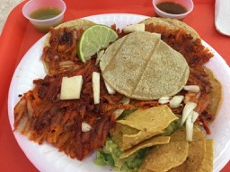
Al pastor tacos in Yucatán are very different than in Sinaloa. I haven’t decided yet if I like them as much or if I need to find a new favourite taco. But these were really good. I couldn’t believe I got all this (which has a very generous portion of Tex-Mex style guacamole under the totopos!) and a real strawberry agua fresca for only $79.
Since I was practically in Mérida, I did a quick blip over to Costco. I was amused to find actual Korean people (there is a sizeable Korean community in Mérida) debating the possible merits of the very kimchi dumplings I was coming to pick up. They put them back…
I got in around 2:00 and by the time I’d played with Puppy and had a swim, it was time for a long chat with a friend by phone, then dinner. It’s now almost 9:00. I forgot how long these posts take to write! At any rate, I hope you enjoyed my morning at Dzibilchatún as much as I did!
Mot sure about as much as you did but I did enjoy it. Nice to feel like you finally got to go play.
Well, you didn’t have to experience a glaring sun, biting insects, and spiky plants… 🙂
It does feel like I went out to play, doesn’t it? 🙂
Time well spent, great pictures and a very informative history lesson. Thanks for sharing.
Thanks for reading. Glad you enjoyed it.
Thanks for sharing your trip with us two! I found that it easier to me to walk diagonally up and down those pyramids than climbing straight up. I tried that first in Chichen Itza and then again in Uxmal.
I’m glad you enjoyed yourself! I also think it’s easier to climb diagonally, but I have no idea why since you’re still hauling yourself up and down the same height steps.
Cool place to walk around and learn new things. I love ruins in Mexico and like to compare them. The food looks good too! Have you made it to the Museum of Anthropology in CDMX? It’s a three-day visit. If you haven’t, you’ll love it.
Haven’t been to CDMX yet (except the airport). Good to know about that I need to plan that long for the museum!