Quick Look at Hinton and Thinking About Jasper

I ended up driving into Hinton for dinner tonight and also to gas up the toad. Highway 16 shoots straight through town and on each side of it are the usual big box stores, including a Walmart and a Canadian Tire. There might be more to the town, but at first glance it doesn’t seem like much.

The restaurant choices were uninspired so being in the mood for shrimp I ended up at Joey’s Only Seafood. Never been to that chain before even though I have lived and traveled through many towns with one. The food was adequate, reasonably priced, and had generous but not not exaggerated quantities. It wouldn’t be my first choice next time I go out for dinner, but for tonight it worked. I had a shrimp and chicken combo with rice and veggies.

I then gassed up the toad, at 91.9! I will make sure to gas up both vehicles at the very limit of Alberta to take full advantage of the price here!

While I had planned to go to Jasper tomorrow, I may end up hanging out at home instead. Both vehicles badly need an exterior cleaning and I have a few things to troubleshoot. There doesn’t seem to be enough to do in Jasper to justify the 140km round trip in the toad, nor paying the park entry fee twice. I might take up Croft’s suggestion from 2008 and instead get up early on Wednesday, park Miranda on the edge of town, and then explore at my leisure. Decisions, decisions. 🙂 Whatever I do, I do not want to spend a night within the park borders; I simply cannot justify paying $40-$50 to boondock on Crown land!!!

Slowing Down

It was a slow, easy drive to Liard Hot Springs last night. I decided to be a tad cheeky, what with a full hookup park next door and dry camping spots available for the exorbitant cost of $21 at the provincial park, and just spend the night in the parking lot across from the park entrance.

Beta Pool was closed because of bear activity, so I had to hang out with a million other people in alpha pool. It wasn’t the most relaxing hot spring experience of my life, so I didn’t soak for long.

It was nice to get back to the rig, shower, and then hunker down for the night. I made a nice dinner, watched a movie, and read.

This morning, nothing short of a natural disaster could have gotten me moving at a speed faster than a crawl. It was the first time in months that I was able to just lie in bed with the cats, read, and know that I had nothing and no one waiting for me. I lingered over coffee and breakfast, then set off around 10:30.

The drive from Liard to Fort Nelson is very technical; lots of tight turns and 7 to 8% grades. It was my first time doing it in that direction and I had a lot of fun. I saw more buffalo and caribou today than in all the sightings I’ve had in my life combined.

I’m going to get some work done, gas up, then head to a turnout I stayed at in the spring of ’09. Tomorrow, I’ll move on to Fort St John or Dawson Creek and then the adventure will begin!

IMGP0598

IMGP0601

IMGP0605

IMGP0606

IMGP0607

IMGP0614

IMGP0619

IMGP0620

IMGP0621

IMGP0622

IMGP0623

IMGP0624

Parks Canada’s Bear Creek Compound

Parks Canada’s Bear Creek Compound is somewhat legendary in Dawson as few have stepped foot in it. Today, for the first time in at least seven years, and possibly for the last time, the compound was opened to the public for a few hours. Checking it out seemed like a good use of my afternoon break!

From the Parks Canada website:

Bear Creek is an industrial complex of some 65 buildings and related structures located in the Klondike River Valley, 10 kilometres east of Dawson City. From 1905 to 1966, Bear Creek was the Klondike headquarters for corporate mining interests, acting as the administrative and repair centre for the goldfield’s dredging operations. These huge dredges worked the goldfields, replacing the small individual miner of the gold rush and ensuring the viability of gold mining as a profitable business up until 1966.

(For a refresher course on dredges, go back to my post about Dredge No. 4.)

Parks Canada acquired the complex in 1975 but because of environmental concerns could not do too much with it. One of the biggest hazards is the mercury that was used in the gold extraction process. The cost of rehabilitating the site to make it safe for the public would be prohibitive. Today, Parks Canada mostly uses the buildings for storage, but there is one garage left for repairing big machinery.

Visiting the compound was an extraordinary experience. The majority of the buildings are in some stage of decay, mostly advanced, and many have artifacts left in situ, as though time has stood still. It reminded me a lot of touring Alcatraz, actually, and the weight of history was incredibly present.

IMGP0461

the mess hall

the mess hall

IMGP0463

IMGP0464

the floors in the messhall undulate like fields of prairie wheat

the floors in the messhall undulate like fields of prairie wheat

IMGP0468

IMGP0469

Parks Canada lumber storage

Parks Canada lumber storage

IMGP0471

IMGP0472

the most impressive building--you open a very heavy and thick door into a dark and earthy-smelling tunnel. My camera's flash did too good a job here!

the most impressive building–you open a very heavy and thick door into a dark and earthy-smelling tunnel. My camera’s flash did too good a job here!

exterior of the root cellar

exterior of the root cellar

tailing

tailing

IMGP0476

IMGP0477

IMGP0478

that yellow never fails to take my breath away!

that yellow never fails to take my breath away!

IMGP0480

IMGP0481

IMGP0482

IMGP0484

this machine was cast in Ohio!

this machine was cast in Ohio!

IMGP0486

decay

decay

IMGP0488

this cavernous building once held all manner of giant machinery

this cavernous building once held all manner of giant machinery

IMGP0490

IMGP0491

IMGP0492

IMGP0493

IMGP0494

a giant transformer

a giant transformer

IMGP0496

permafrost wreaking havoc in the tin shop

permafrost wreaking havoc in the tin shop

IMGP0499

IMGP0500

IMGP0501

IMGP0502

IMGP0503

IMGP0504

IMGP0505

IMGP0506

55 cents a gallon!

55 cents a gallon!

IMGP0509

IMGP0510

IMGP0511

this building is obviously in modern use. :)

this building is obviously in modern use. 🙂

IMGP0513

incredible!

incredible!

IMGP0515

IMGP0516

IMGP0517

IMGP0518

this tunnel is just about tall enough for me to crouch in!

this tunnel is just about tall enough for me to crouch in!

coming apart at the seams

coming apart at the seams

IMGP0522

exterior of the steno office

exterior of the steno office

IMGP0524

IMGP0525

staff housing (doesn't look much better from the exterior than any of the other buildings!)

staff housing (doesn’t look much better from the exterior than any of the other buildings!)

IMGP0527

this shed holds 'props'

this shed holds ‘props’

the engineer's house

the engineer’s house

IMGP0530

this house surprised me with the number and size of rooms it contains, as well as the ample storage

this house surprised me with the number and size of rooms it contains, as well as the ample storage

IMGP0532

toilet room off a massive bathroom

toilet room off a massive bathroom

IMGP0534

IMGP0535

news article about Neil Armstrong!

news article about Neil Armstrong!

IMGP0537

1962 calendar (I suspect it was planted here; seems in too good shape)

1962 calendar (I suspect it was planted here; seems in too good shape)

information about Bear Creek

information about Bear Creek

blank forms

blank forms

IMGP0541

IMGP0542

wheelbarrow dug out of the permafrost

wheelbarrow dug out of the permafrost

IMGP0544

IMGP0545

the staircase inside the welcome building is in surprisingly good shape

the staircase inside the welcome building is in surprisingly good shape

IMGP0547

IMGP0548

the interior of the engineering building is in excellent condition

the interior of the engineering building is in excellent condition

IMGP0550

adding machine

adding machine

IMGP0552

IMGP0554

IMGP0462

IMGP0478

I feel privileged to have had the opportunity to tour the Bear Creek compound. What a way to conclude my stay in the Klondike!

Driving the Dempster: Eagle Plains to Inuvik

I was up insanely early at Eagle Plains (sleeping on the ground will do that to you). I made some coffee and oatmeal, broke camp, and heading off around 7AM. There’s a time zone change to Mountain Standard Time when you hit the Northwest Territories, so I figured an early start would make up for the lost hour.

This second half of the Dempster has a lot of milestones. The first was, of course, the crossing of the imaginary line known as the Arctic Circle. We humans make such a fuss over other imaginary things like time and mathematics and borders, so why not a line around the earth? 🙂

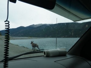
Next, I crossed over into the Northwest Territories! I just have one province and one territory left to visit! Shortly after that, I had the second grizzly sighting of my life. I didn’t see much wildlife on this trip, but a grizzly more than made up for that!

A couple hours after Eagle Plains, I hit the first of the two ferries, that at the Peel River. The approach to it was incredibly steep and I scraped the whole bottom front of my car getting on. It was annoying to be getting the ‘hurry up!’ motion while I was trying to avoid making any damages worth mentioning! This ferry runs on a cable, shots of which I got on my return trip, so I will be returning to this place in a few posts.

After the ferry, I pulled into the Nitainlaii Territorial Park entrance to use the outhouse. Since I was there, I figured I might as well go into the interpretive centre and see what was what. The door wasn’t even open yet that I was cheerfully greeted by an Elder who was obviously eager to chat with someone new. We talked about road conditions and then he uttered some of the most beautiful words in the English language: “I have coffee.” I had a cup with hazelnut creamer and set back off.

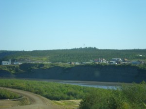
I then came across the community of Fort McPherson, known for its canvas products such as tents and bags. The factory wasn’t open yet for public viewing and there wasn’t much else to see in this tiny town, so I pushed on towards the second ferry crossing.

The tiny village of Tsiigehtchic, at the confluence of the Arctic Red and Mackenzie Rivers, is a sight to behold; so picturesque with its white church and set against emerald greenery. I had thought to detour there, but the ferry approaches being what they were, I wasn’t too motivate to risk damage to the car.

This ferry crossing features a larger boat which travels in a triangular pattern: south shore of the Mackenzie, then Tsiigehtchic, then the north shore. As a side note, the Arctic Red River should not be confused with the more southern Red River that passes through Winnipeg.

The wait for this ferry was much longer than for the Peel River and I also had to detour to Tsiigehtchic to let off a car. When I saw that it had trouble getting off, I decided I’d made a good decision to not get off, too.

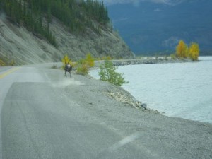
The Mackenzie River is the longest in Canada and the eleventh longest in the world. This is a fact that was drilled into me in my elementary geography classes and I was not disappointed by the river in the least! It is big and wide and most impressive.

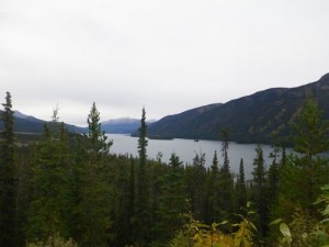
There’s a nice view point (or veiw point according to the NWT) shortly before Inuvik. I enjoyed the short walk up to the lookout platform, where I was awed by all the trees! Where was the barren Arctic I’d read about?!

Some more kilometres passed and then, just like that, I hit pavement and the Inuvik airport. I felt so accomplished at knowing that I’d made it through the Dempster unscathed, but I never forgot that I’d have to do it again!

30 minutes from Eagle Plains, I crossed the fabled Arctic Circle

30 minutes from Eagle Plains, I crossed the fabled Arctic Circle

about the Arctic Circle

about the Arctic Circle

about the Arctic Circle

about the Arctic Circle

view at the Arctic Circle

view at the Arctic Circle

view at the Arctic Circle

view at the Arctic Circle

when I bought this car, I had no idea that it would take me to such wonderous places...

when I bought this car, I had no idea that it would take me to such wonderous places…

about the Arctic Circle

about the Arctic Circle

about the Arctic Circle

about the Arctic Circle

view at the Arctic Circle

view at the Arctic Circle

text about pingos (more on those in a later post)

text about pingos (more on those in a later post)

view at the Arctic Circle

view at the Arctic Circle

about the Arctic

about the Arctic

yet more about the Arctic Circle

yet more about the Arctic Circle

still more views at the Arctic Circle

still more views at the Arctic Circle

entering the Northwest Territories!!!

entering the Northwest Territories!!!

the Northwest Territories at last!

the Northwest Territories at last!

standing between the Yukon and the Northwest Territories

standing between the Yukon and the Northwest Territories

first glimpses of the NWT

first glimpses of the NWT

first glimpses of the NWT

first glimpses of the NWT

IMGP0186

IMGP0188

grizzly!

grizzly!

grizzly!

grizzly!

grizzly!

grizzly!

on the Peel River ferry

on the Peel River ferry

IMGP0193

IMGP0194

approaching Fort McPherson

approaching Fort McPherson

IMGP0196

Tsiigehtchic

Tsiigehtchic

confluence of the Mackenzie and Arctic Red Rivers

confluence of the Mackenzie and Arctic Red Rivers

the mighty Mackenzie

the mighty Mackenzie

waiting on the Mackenzie River ferry

waiting on the Mackenzie River ferry

waiting on the Mackenzie River ferry

waiting on the Mackenzie River ferry

waiting on the Mackenzie River ferry

waiting on the Mackenzie River ferry

this unfortunate spelling error was to be found at other points in my journey...

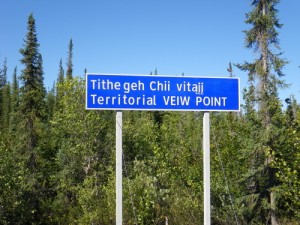
this unfortunate spelling error was to be found at other points in my journey…

IMGP0207

IMGP0208

IMGP0209

never thought I'd see trees like that this far north!

never thought I’d see trees like that this far north!

IMGP0211

IMGP0213

IMGP0214

and then, just like that, PAVEMENT!

and then, just like that, PAVEMENT!

and lane markers!

and lane markers!

what a drive!

what a drive!

Kluane Country

Kluane National Park is one of those regions that, like Kananaskis Country in Alberta, has inflamed my imagination for years. While I would love to explore the region in depth and camp there, just a brief day trip into those fabled peaks was enough to satisfy the itch.

After the car repairs, I headed west on the Alaska Highway and, for the first time, pushed past the turnoff to the North Klondike Highway. The landscape became arid, with soft round peaks rippling through, grey and weathered, reminding me of elephant skin. The road imitated the mountains, with one frost heave after another threatening my suspension. I would not have enjoyed this ride with Miranda!

And then, just like that, they were before me, the Kluane Ice Ranges, just as I had always envisioned them. Pointy, slate grey, and snow covered. Beautiful.

I only went as far as Haines Junction, heart of Kluane Country, and turned back. And it was enough for this current incarnation of my traveling life. I would love to come back that way again, in another version of this life where I have more time to explore the territory, but it was enough.

pushing west on the Alaska highway

pushing west on the Alaska highway

CIMG0002

Takhini Valley

Takhini Valley

CIMG0004

Takhini Valley

Takhini Valley

CIMG0006

CIMG0007

CIMG0008

CIMG0009

first glimpse of the Ice Ranges!

first glimpse of the Ice Ranges!

info about Kennedy and Hubbard peaks

info about Kennedy and Hubbard peaks

CIMG0012

You can clearly see the Hubbard peak in this photo, but the Kennedy peak is very faint. They are the white bit between the darker mountains.

You can clearly see the Hubbard peak in this photo, but the Kennedy peak is very faint. They are the white bit between the darker mountains.

CIMG0014

entering Haines Junction

entering Haines Junction

downtown Haines Junction set against the Ice Fields

downtown Haines Junction set against the Ice Fields

Haines Junction, by the way, is tiny, little more than a swell on the highway, and should not be confused with Haines, Alaska. Alaska Highway travelers headed for Fairbanks should note that they should turn right at Haines Junction for Fairbanks rather than going straight to Haines. I think that someone was trying to confuse the tourists. 😀