Angels Landing is one of the most famous hikes in Zion National Park and also one of the most notorious in the national parks system. After climbing a series of switchbacks to Scouts Landing, you continue on a narrow exposed ridge, with the odd chain to use as a handhold, until getting to the famed Angels Landing, a plateau with stunning views of Zion Canyon. Since 2004, there have been six deaths on this trail.
I did a lot of research about the trail. It seemed that the two most dangerous parts of it are crowds and bad weather, in addition to personal issues like fear of heights, bad footwear, physical condition, and lack of respect for the trail. My gut reaction after reading all this was NO WAY. But I still decided to climb to Scouts Landing and see at least the start of the Angels Landing hike to get a feel for it myself. My biggest concern was my knees and whether they could get me up and down safely. The right one has the nasty habit of popping out of its socket with little provocation and is probably the most dangerous enemy I face on a technical hike.

View from my bus stop in Springdale.

The shuttle stops in both town and the park look like this.

Cute antique store across from the bus stop.

You are discouraged from relieving yourself on the trail and encouraged to use the Grotto toilets before heading up. There is also a very smelly porta potty at Scouts Landing.
I arrived at the trailhead at 10:00 this morning. Research suggested arriving very early to beat the crowds and weather, but it being late October, I wasn’t worried about either.

I saw this sign warning about deaths on the trail several times along the way.

Angel’s Landing. From that vantage point, I was still in NO WAY mode.

2.5 miles to Angel’s Landing. Sounds short…
The route to Scouts Landing starts off gently, but quickly pushes upwards with a series of low grade switchbacks. After the last nasty one, the first where I really needed to stop and catch my breath, you enter Refrigerator Canyon where you get a bit of a break. The canyon is very sheltered and cool, hence its name.

At the base of the canyon.

Sun drenched peaks.

Climbing.

This was the first really tough climb. I took a good break after this one!

Holes carved into the sandstone.

Refrigerator Canyon was a nice break.

Beautiful contrast of hard red stone and soft green foliage.
After the canyon, you go up, along Walter’s Wiggles, a series of tight switchbacks that cut into the side of the mountain. They were designed by a man with no engineering background and are quite an accomplishment, making the climb to Scout’s Landing manageable.

The tight switchbacks are held in place with these beautiful sandstone walls.

Looking up to the top of Walter’s Wiggles.
I was surprised when I reached Scouts Landing in less than hour, thinking, ‘That’s it for today?!’ The hike up was steady and not too strenuous. It was amazing to see the canyon floor get smaller and farther away. This is a hike that anyone who is moderately in shape can do easily if they take their time. It’s paved or sandy all the way and there’s no clambering.

The canyon from Scout’s Landing.

More of the canyon from Scout’s Landing.
I had lunch while I contemplated going on to Angels Landing. Finally, I went to the trailhead and saw that the first section was a series of switchbacks along a cliff face with a few chains for support.

Another reminder about the perils of the hike.

The first section looks way worse than it actually is. In fact, that’s how I feel about the trail. You can’t judge it from pictures and videos.
A gentleman came off the trail and saw me staring. He said that he must have had the same look on his face when he started and that he was certain that the trail was ‘a step too far. ‘ But he did it and said that it was not that bad and that the view at the end was worth it. He also pointed to my feet and said that he couldn’t imagine better footwear than my Keens. We chatted some more and he told me I’d run out of excuses and to go on. I took a deep breath and headed to the base of the slope.
My biggest fear wasn’t falling. It also wasn’t trying the hike and turning back. My biggest fear was that I would do it and come out of it thinking that I was stupid for putting my life at risk for nothing. I decided that the first bit looked very doable and that the risks were minor. I would assess each section of the trail that way and turn back the minute alarm bells would ring in my head.
To my surprise, the half mile to Angels Landing progressed quickly, one section at a time. There was a lot of clambering, but not a single moment where my fear of heights reared its ugly head. I felt secure and quite agile, even on the more exposed sections where one wrong step would have sent me tumbling over a thousand feet to the canyon below.
I reached a landing that I thought at first was the end and was surprised that the journey had been relatively easy. But then I saw what lay ahead, the climb up the narrow ridge, and I almost made the decision to quit. But I’d come so far and I decided to continue taking it just one section at a time, watching my foot falls, and moving out of the way for larger groups and faster folk.

Taking a breather at the first landing.

Here’s the infamous ridge section. I am so glad I pushed on and checked it out instead of letting this view make the decision for me.

See, not so bad. Lots of hand and footholds. 🙂
That section wound up being no worse than the first and I soon reached a second plateau. I was in great shape psychologically, but my legs were getting a little shaky from the exertion. I was worried about stamina for the trip down, so I took a long break and asked hikers coming down if there was far to go. Nope. Indeed, there was one more clamber and then I was on Angels Landing!
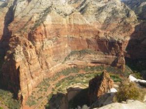
The view from the plateau was breathtaking, of course. The canyon was so far below us that it didn’t even seem real. We all helped each other out getting photos and took a break. A huge apple did wonders for my shaky legs.

First view from Angel’s Landing!

Here I am on Angel’s Landing!
Yup, I just leaned over the edge and took a picture of the canyon. I’m not convinced I am scared of heights! 🙂
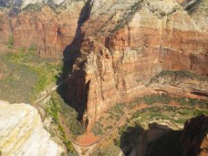
Another view of the canyon below.

Interesting rock formation on Angel’s Landing.
I sat for a bit soaking in the view, but knew that I couldn’t put off the descent forever. When I got up, I found my knees had already stiffened up and they cracked loud enough in the first steps across the landing for someone to ask what the sound was!
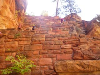
The descent wound up being positively anticlimactic! When I reached Scouts Landing, I was shocked that I was there. The switchbacks at the beginning that I had dreaded doing again were a non-event! The only bit of note on the way down was actually a climb. There was no logical easy way up, so I lifted a leg super high up onto a ledge and then used my upper body strength and a handy chain to propel myself upwards. I heard the guys behind me go, ‘Woah, nice one!’

Here’s that hard section going back down (actually up). You can see that the girl is struggling to find a close enough foothold.
From Scouts Landing, it was a very long and painful descent back to the canyon floor.

So far too go!
Going down is always worse on the knees than the cardio is on the lungs going upwards! I was glad when I reached the Grotto. From there, I hiked the half mile back to Zion Lodge by way of the Grotto Trail. There, I treated myself to a well deserved ice cream!

Photo of the original Zion Lodge, which burned down and was quickly rebuilt. The current lodge has guest cabins and a café.

$3 for quite a large cone was quite reasonable considering the location.
So here’s my take on the Angels Landing hike. First of all, I think that it should be permitted in the summertime to limit the number of hikers on the trail. I am convinced that crowds are what make this hike so dangerous. There were just enough people on the trail today for me to feel safe that there was help nearby, but not so much that I found myself hugging a cliff face waiting for people to pass. I did have long breaks to let groups get past me, but I didn’t mind that at all. I also think the trail should be closed in winter to prevent slipping on ice.
Next, the hike is rated as strenuous. For me, it was the perfect physical level, somewhere in the lower end of moderate as it is work, but it’s not super exerting. I honestly did not find it particularly challenging, beyond the knee issues that tend to make me look skittish, especially on descents when I have to decide if I’m going to step down with the left or right leg, which depends on how the other leg will be positioned until it can come down, too. I have a decent amount of upper body strength, so I definitely made use of the chains to pull myself up some sections, which helped.
My Keens were definitely the perfect shoes for this hike, affording me a good grip on the rock but also lots of flexibility. I would not have wanted to do this hike with big heavy boots or in flip flops or running shoes the way some people did today!
Finally, I had absolutely no problem with the height issues on this hike. I didn’t have a single moment of terror where I thought, ‘No way!’ and have to push myself through. I felt secure the whole way. Again, I think it helps that there weren’t huge crowds, so I could choose when to pull over to let people pass. I didn’t make any particular effort to avoid looking down or anything like that. I’ve either gotten over my fear of heights and falling or there were no triggers on this trail. Not sure which.
To sum up, for me the Angels Landing hiking trail in late October with perfect weather (clear and not too hot or windy) and small crowds, was fun. I am thrilled that I did it and don’t feel like an idiot who risked death to tell a great story. I love clambering around on rocks and finding a way up and down. This hike seemed to be perfectly designed for me! I would love to do it again!
From the Zion Lodge, I took the shuttle back to the welcome centre, stopping at the Court of the Patriarchs to view some peaks. The hike up to that viewpoint was my limit for the day!

At Court of the Patriarchs, there is a panel about the 1995 slide that washed out part of the road, trapped people at Zion Lodge, and forced an evacuation of Watchman Campground.


The patriarchs are, left to right, Abraham, Isaac, and Jacob. Jacob is white. The red peak in front is Mount Moroni.

These cacti are rather close to the path and have big spines!

The town shuttle had five seats across the back. Never seen that before.
Tomorrow is going to either be a work or a driving day. I am going out to Kolob Canyons, but I could easily postpone that to Tuesday and take off for Arizona on Wednesday. Just waiting to see if the work comes in or not.