Lynn Canyon Park

Today promised to be a gorgeous, springy day, with sun and highs in the double digits. Things have started to dry out considerably and I was just itching to get out of the city and enjoy a hike in the woods. My first instinct was to visit the Capilano Suspension Bridge. It’s not a cheap excursion (30$ entrance fee plus 5$ for parking), so I did some research on tripadvisor.com to see if it’s a tourist trap. Apparently, yes, because nearby Lynn Canyon offers a comparable experience at a price that can’t be beat: FREE!

Free sounded especially good since I wasn’t sure I’d actually get across a suspension bridge. I sure didn’t the last time I was faced with one!

Well, it seems that continued exposure to suspension bridges and a gondola ride have made me a little less of a scaredy cat and I wound up crossing the Lynn Canyon Suspension Bridge no less than THREE times! I will admit that I got across as quickly as possible, didn’t stop to take in the scenery, and shook like a leaf the whole way, but what progress!

Lynn Canyon is situated in the heart of a temperate rain forest and is a world of towering redwoods and pools of clear emerald water. Until today, I’d only seen water that clear and beautiful in Alberta. I spent two glorious hours enjoying the perfect weather (mid-single digits there) taking the first steps to getting in shape for the Chilkhoot hike. I finished my morning with a picnic lunch and then a stroll through the excellent Ecological Centre (2$ suggested donation).

Pictures are on the Lynn Canyon page.

Something wondrous happened today. I don’t know if it was the weather, the minimal GPSing I needed to do to get around, the amazing lack of traffic, nature, or what, but I… Oh, the English language is failing me here. In French, I’d say ‘apprivoisé’, which means tamed, but not quite for this context. I guess I’ll say I made my peace with the GVR, found something about it to love, discovered a little corner of it where I was happy to leave a tiny piece of my soul. The GVR is no longer a big, bad scary urban enclave (shootings notwithstanding), but a place that I will remember as being ‘home’ for four months in 2009.

Good day. 🙂

Stanley Park

World famous Stanley Park is located at the northern tip of the city of Vancouver. It is the largest city-operated park in Canada and the third largest in all of North America.  It is a 1,000 acre (405 hectare) urban oasis and the only thing I’ve always known I’d want to see if I ever made it to Vancouver. Among its many attractions are the totem poles and the Vancouver Aquarium.

Well, the weather’s been improving and been alternating between sun and fog, so I decided that today was going to be The Day. I was going to brave Vancouver and visit Stanley Park!

First decision to make was how to get there. I really wanted to use the Skytrain, but Stanley Park is huge and its shuttle doesn’t run in the winter. If I wanted to see anything, I’d have to go by car.

The drive wasn’t that bad, actually (thanks, Majel!), and I had a lovely morning in this beautiful park. I’m going to go back on a nicer day so I can get some proper shots of the city. The fog over the ocean was really thick this morning!

The aquarium was okay. I had a nice time and saw some cool things but I’ve been spoiled by some of the best aquariums our continent has to offer, so it takes a lot to wow me now when I visit such a facility. I think that what I will remember most about the Vancouver Aquarium is the beluga whales!

The most memorable moment of the day was when I came across a couple arguing in Mandarin about what they were seeing in the fog:

Lady: Shi Lionsgate Bridge! (It’s the Lionsgate Bridge!)

Man: Bu shi Lionsgate Bridge! (It’s NOT the Lionsgate Bridge!)

Back and forth for a whole minute until I had enough and exclaimed: “SHI Lionsgate!” Then, off their stunned gaze “Wode hanyu pu xin.” (My Chinese sucks) Whodathunk my 15 weeks of Mandarin lessons back in 1997 would come in handy one day? 😀

Please check out the Stanley Park page for pictures. 🙂

Adventures In No Man’s Land

Here is the daytime view at my new park. Yes, I need to wash my windows. The roads were sandy yesterday! 🙂

daytime view at PB

Walking down Zero Avenue, I was treated to this sight:

Spelling Fail

Spelling Fail

*ggl*

Then this little guy stopped his wanderings long enough to pose for a couple of shots!

deer1

deer2

Notice the water of salty persuasion in the background… 🙂

Getting closer to the water:

5nml

Zero Avenue ends at Peace Arch Park, a sort of no man’s land that straddles the 49th parallel, existing between the American and Canadian customs. I don’t know if Americans can do this, but I was able to take a stroll down Zero Avenue in Surrey right into the park without requiring any sort of identification. I was told I could walk to White Rock through the park, but I couldn’t find a legitimate way to get out of there other than the way I came in or actually going through Canadian customs, so I didn’t pursue the issue and will ask for further clarification.

A not-so-excellent adventure on a US military base in California taught me to be very careful about taking pictures anywhere near US government installations (no, I did NOT try to take pictures of a military base!), so I was very cautious about taking out the camera at the park. I did sneak a couple of pics:

I'm in the United States!

I’m in the United States!

Otherside of the monument... and I'm in Canada!

Other side of the monument… and I’m in Canada!

More ocean, a lineup to get into the US, and a glimpse of Peace Arch Park

More ocean, a lineup to get into the US, and a glimpse of Peace Arch Park

9nml

The Peach Arch

Coming home, I passed a couple out for a stroll:

Mr. and Mrs. Mallard out enjoying the weather

Mr. and Mrs. Mallard out enjoying the weather

When I checked the forecast last night, they were calling for rain today and the rest of the week, but it’s been sunny so far. What a reprieve!

The Best Laid Plans…

Wow. I sure didn’t expect to be here today, here as in the Okanagan Valley, here as in the capital of wine country, here as in the end of the road for the next month.

Yesterday didn’t quite go as planned. By the time I stopped for the night, I was sure that I couldn’t possibly ever again have a worst day. By the morning, though, I was grinning and realising that nothing, absolutely nothing, will ever be as bad as that crunching day between Thunder Bay and Selkirk.

But let’s start at the beginning, shall we?

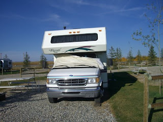
Here’s Miranda at the Spring Hill RV Park 9km north of Cochrane, Alberta:

Cochrane is quite possibility the most beautiful full service town I have ever visited, even more beautiful than Banff. I could have easily stayed a few months there.

I left the park almost two hours earlier than I had planned. I’m grateful that they had propane and gas fill up stations, so I was able to do everything there before pushing off. All of that, plus the one hour time shift and the week’s rest I just had meant that I was ready to drive if conditions warranted it. Tourism time had ended and it was time for me to get to work. I’d have plenty of time to come back into the mountains to explore in later months.

So, I made it to past Revelstoke yesterday, about 480km, but it wasn’t a drudging sort of drive because I did make the time for two touristy stops, one of which was an hour and a half long.

This stop was, of course, at Lake Louise.

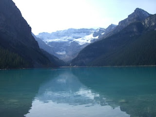
As I expected, Lake Louise is 100% a tourist trap. Oh, the lake is definitely worth the long climb up a narrow winding road, but I can’t believe that people are saps enough to pay 55$ for a one hour canoe trip on the lake. Just call me the cynic. Or maybe I’m just frugal. 🙂 Having had lunch in the rig and craving dessert, I went into the Chateau

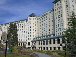
to look for ridiculously overpriced ice cream to munch on while I walked partway around the lake and was delighted to find merely overpriced ice cream.

My next stop was at the Spiral Tunnels. I waited almost a half hour there hoping to see a train go through them, but I finally had to press on. The pictures I took here don’t really show anything, so I won’t post them. Very briefly, the Spiral Tunnels were an answer to the Big Hill, a really steep bit of Transcanada rail line between Field, BC, and Kicking Horse Pass. This hill cost a fortune to run and was the scene of many accidents. The spiral tunnels cut into the mountain reduced the grade by 50%. I really can’t do the story justice, so you’ll just need to go read the Wiki article. 🙂

Then, I drove.

My first possibility for an overnight stop was the Kicking Horse rest area, just west of Yoho National Park. Unfortunately, it was only 3PM local time when I arrived there and there was blasting and other construction going on. So, I pressed on, surprised to find myself already going through Glacier and Revelstoke Parks.

Just west of Revelstoke, I found what seemed like an informal truck stop, but it looked very busy and noisy, so I pressed on.

Then, I found what seemed like the perfect stop to stop for the night. There was a rest area with a road leading down to a utility shed, with a large open area. It seemed private and quiet, so I decided to make that my stop for the night.

Which is when I discovered that I had absolutely no power. Now, my batteries were fully charged, but no power was getting through to my 12V system. I check the terminals and my fuse box, trying to figure out what had happened in 5.5 hours to break my electrical system! It was about to get dark and I decided to drive 10km. If I didn’t find an RV park within that time, I would come back to this spot and tough out the night without power.

As I drove, I suddenly remembered Croft’s suggestion that I try to start the generator with the truck engine running. So, having passed two closed RV parks and being ready to turn around, I pulled into a rest area and tested his trick. It worked! I had power! Noisy power, but at least my fridge was running again. I decided to go back to my previously selected spot when I realised that I didn’t need to. This rest area was built a bit like a tea cup. I was parked in the bowl. To the right of me was a thicket of trees and there was a narrow path going around this thicket, like a handle. I pulled into it and to my delight found myself tucked away out of sight of the road. It wasn’t as quiet as the other spot would have been, but at least I didn’t have to double back. It was fully dark now and pouring rain, so I was very, very grateful that my day of driving was done.

I set to work making dinner, then I read for a couple of hours. I went to bed ridiculously early, about 8:30 local time, but it was 9:30 my time and I was beat!

For a first time pulling off the road and sleeping in the middle of nowhere, I slept pretty well. I woke up around 1, then slept soundly again until 5. I ran the generator again for a couple of hours as I puttered around, waiting for it to be light enough out for me to set off. This kept most of the contents of the freezer frozen solid, thankfully, and used up only a negligible amount of gas. I can almost get used to the noise inside, but would hate to run the generator when there are people around!

So, my first day in BC dawned like my first day in Manitoba, very rainy and foggy. I decided to drive until such time as the weather cleared up and run the generator again for about an hour for the fridge’s benefit, then I would make a straight run for Oliver where hookups would give me time to figure out what was going on with my electrical system.

I was in a really good mood this morning. I’d slept well, had an indecently yummy cup of coffee while watching the sun rise at the rest stop, and realised that the part of my journey I had feared the most was over: I was clear across the mountains! Sure, part of the day before had sucked (driving in the dark in rain with no power and chicken about to thaw in the freezer), but, sum told, it had actually been quite a good day. I was especially proud of myself for being able to recognize a good place to stop and, most importantly, for not pushing myself any further than I absolutely needed to.

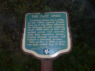
So, I set off in pea soup fog and made a quick stop at the site of a major event in Canadian history:

And that was it for tourism. I drove quickly through Vernon and Kelowna, glad when I saw them that I wasn’t stopping there for my week of reconnaissance, and then I pulled over at a rest stop outside of Penticton for lunch (thawed out pizza that I hadn’t been able to stuff into the colder part of the freezer with all the other stuff that was still, thankfully, frozen solid).

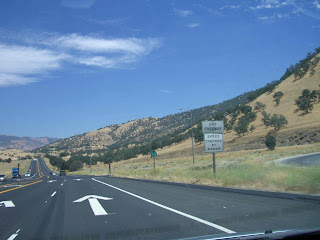
The Okanagan area looks quite like I expected it to, except for the hills which remind me of the Sierra Nevadas!

Okanagan Valley

Sierra Nevadas

I’m now settled for a week just outside of Oliver, which is the wine capital of Canada. I passed too many wineries to count on the drive down here, so I think I’ll just start at the closest one to here and work my way south to Osoyoos, and then north again, asking at each one if they’re hiring pickers yet. Tomorrow, though, I just might take the morning for a wee bit of sightseeing as I am very eager to see Canada’s only (non-Arctic) desert. But, after that, it’s time to look for work!

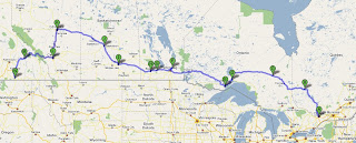
So, the first stage of my great big adventure has ended. I have successfully traveled the roughly 5,000km (not counting mileage done with the toad) that separated me from my old life in Gatineau to the new one awaiting me in the Okanagan Valley. I arrived here a lot less naive and cocky, but in excellent spirits and with a month’s worth of memories that make up for a lifetime of disillusionment.

Now that my rig is well broken in and I am more knowledgeable, it’s time to think about finding work, a place to spend the winter, and a way to make Miranda comfortable during that season.

In a way, I feel that my journey is still just beginning. Today is not an ending, just a really, really, really major milestone.

Calgary, My Enchanted Land, and the End of the Road?

Calgary

CIMG0001

CIMG0002

CIMG0003

CIMG0004

CIMG0005

CIMG0006

CIMG0007

CIMG0008

CIMG0009

CIMG0010

CIMG0011

CIMG0012

CIMG0013

CIMG0014

CIMG0015

CIMG0016

CIMG0017

CIMG0018

The only thing on my schedule for today was a visit of Fort Calgary.

CIMG0019

It’s a small museum, but the exhibits about the NWMP and the history of Calgary are quite interesting. I was accosted at one point by a retired RCMP officer who proceeded to talk my ear off for about twenty minutes about his career, his uniform, Mountie training, career opportunities within the force, his son who is serving at the detachment in Inuvik, our mutual feelings about Ottawa vs. The West, and more. It was really interesting!

As I was about to leave the fort, the lady at the admissions desk called me back and gave me some information about another museum that might interest me that is only open tomorrow (more about that tomorrow *g*) and then she gave me information on a walking tour of downtown Calgary, a scenic detour on the way to a cemetery, details on how to find a particularly interesting gravestone, a brochure about a rock garden that is a must see, and, finally, a map illustrating filming locations in the Calgary area. Whew!

I did only part of the walking tour, which was mostly a gentle stroll down Stephen Avenue, Calgary’s former main street. The architecture was exquisite!!! During a pre-WWI boom, a lot of Calgary’s original wooden buildings were replaced by sandstone structures that really reflect the amount of wealth coming into the city at the time. The Doll Building was my favourite.

The Hudson’s Bay store left me awestruck. It takes up a whole block!

CIMG0020

CIMG0021

CIMG0022

CIMG0023

CIMG0024

CIMG0025

CIMG0026

CIMG0027

CIMG0028

I then returned to my car and proceeded to Spiller Avenue, from which she told me I should take the steepest side street I could find and that I would know why at the top; all of Calgary was laid out below me!

CIMG0029

CIMG0030

CIMG0031

CIMG0032

CIMG0033

CIMG0034

CIMG0035

Next on the list was the cemetery.

The Reader Rock Garden was attached to the cemetery. I enjoyed clambering up and down the stone paths even if there wasn’t much in bloom at this time of year.

CIMG0037

CIMG0038

CIMG0039

CIMG0040

CIMG0041

CIMG0042

CIMG0043

CIMG0044

CIMG0045

CIMG0046

CIMG0047

CIMG0048

CIMG0049

CIMG0050

CIMG0051

CIMG0052

CIMG0053

CIMG0054

CIMG0055

CIMG0056

CIMG0057

CIMG0058

CIMG0059

CIMG0060

CIMG0061

CIMG0062

It was two by this point and I had nothing else planned for the day. So, I took a gander at the movie locations map. You wouldn’t believe the number of major Hollywood pictures filmed in the Calgary area, everything from Robin Williams’ ‘RV’ to Clint Eastwood’s ‘Unforgiven’ to Ang Lee’s ‘Brokeback Mountain’ (a lot of which was filmed near the town on the outskirts of which I’m currently living).

My Enchanted Land

Until the late ’90’s, I could recognize a certain landscape, or a variation thereof, in numerous movies, but I didn’t realise that it was truly one landscape from one region. It was a landscape of mountains, plateaus, and valleys; the perfect setting for everything from ‘Legends of the Fall’ to ‘The Edge’, movies set in a gentler time or about a rough wilderness. Then one day I watched the dueSouth episode ‘Call of the Wild’ and recognized this landscape in it. I did some research and discovered that my enchanted land is called Kananaskis country and it is in Alberta.

Why my enchanted land? There is a book I reread many times in my youth called ‘Cat, Herself.’ It tells the story of a family of tinkers in Scotland. Tinkers are travelers not unlike the full-time RVer. The main character, Cat, had a grand-mother who referred to Ben Loyal as her enchanted land. The expression stuck in my mind.

So, looking at the movie locations map today, I noticed a route marked the Kananaskis trail. It looked like perhaps three to four hours driving time total.

I wanted to go, but I hesitated. What if my enchanted land turned out to be two beautiful peaks surrounded by condos? Perhaps I should do what I did in 1998 when I purposely avoided Sherwood Forest, just leave it as a land out of dreams.

But I was so close. I decided to go.

I’ll let just a few of the pictures I took tell the rest of the story.

CIMG0063

CIMG0064

CIMG0065

CIMG0066

CIMG0067

CIMG0068

CIMG0069

CIMG0070

CIMG0071

CIMG0072

CIMG0073

CIMG0074

CIMG0075

CIMG0076

CIMG0077

CIMG0078

CIMG0079

CIMG0080

CIMG0081

CIMG0082

CIMG0083

CIMG0084

CIMG0085

CIMG0086

CIMG0087

CIMG0088

CIMG0089

CIMG0090

CIMG0091

CIMG0092

CIMG0093

CIMG0094

CIMG0098

CIMG0099

CIMG0100

CIMG0101

CIMG0103

CIMG0105

CIMG0106

CIMG0107

CIMG0108

CIMG0109

CIMG0110

CIMG0111

CIMG0112

CIMG0113

CIMG0114

CIMG0115

CIMG0116

CIMG0117

CIMG0118

The End of the Road?

There is so much work here in Alberta, more jobs than there are workers. From an employment point of view, this should be the end of the road for me until the spring. But I really don’t think that Miranda could be made comfortable enough to endure a Calgary winter and I’ve endured enough miserable winters in the mobile home to know what I’d be getting into. But all these jobs! So, I’ll confess that I’m looking, just for curiosity’s sake, for an indoor place where I could park Miranda for the winter and live in her, like a heated garage or plane hangar.

To give you an idea of what the employment situation is like, let’s go back for a moment to my very first morning in Alberta, back when I was in Lloydminster. I decided to treat myself to a Tim Horton’s coffee before pushing off. I went in, ordered my coffee and muffin, and was about to leave when someone called to me. It was the manager. He wanted to know if I owned the RV outside and, if so, if I’d be interested in a couple of weeks worth of work.

I haven’t shared that story because I felt no one would believe it. But the woman at the museum today did and she said she had a job for me for the winter if I wanted it.

That doesn’t make actually looking for work particularly appealing.